Laurel, Florida
Laurel, Florida | |
|---|---|
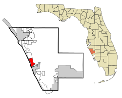
 Location in Sarasota County and the state of Florida | |
| Coordinates: 27°8′29″N 82°27′44″W / 27.14139°N 82.46222°W[1] | |
| Country | |
| State | |
| County | Sarasota |
| Area | |
| • Total | 10.18 sq mi (26.38 km2) |
| • Land | 9.08 sq mi (23.52 km2) |
| • Water | 1.10 sq mi (2.86 km2) |
| Elevation | 10 ft (3 m) |
| Population (2020) | |
| • Total | 12,186 |
| • Density | 1,341.92/sq mi (518.13/km2) |
| Time zone | UTC-5 (Eastern (EST)) |
| • Summer (DST) | UTC-4 (EDT) |
| ZIP code | 34272 |
| Area code | 941 |
| FIPS code | 12-39600[3] |
| GNIS feature ID | 0285395[4] |
Laurel is a census-designated place (CDP) in Sarasota County, Florida, United States. The population was 12,186 as of 2020 census, up from 8,171 at the 2010 census. Laurel is part of the North Port–Bradenton–Sarasota, Florida Metropolitan Statistical Area.
Geography
[edit]According to the United States Census Bureau, the CDP has a total area of 6.1 square miles (15.8 km2), of which 5.1 square miles (13.2 km2) is land and 0.97 square miles (2.5 km2), or 16.13%, is water.
Demographics
[edit]| Census | Pop. | Note | %± |
|---|---|---|---|
| 1990 | 8,245 | — | |
| 2000 | 8,393 | 1.8% | |
| 2010 | 8,171 | −2.6% | |
| 2020 | 12,186 | 49.1% | |
| U.S. Decennial Census[5] | |||

As of the 2020 United States census,[6] the population of Laurel was 12,186 with 5,572 households resulting in a persons per household rate of 2.02.
By age, the population was split with 2.8% under 5 years old, 12.5% under 18 years old, and 42.1% 65 years and older. 50.2% of the population were female persons. By race, the population was split with 88.9% white, 2.8% black, 0.3% American Indian and Alaska Native, 2.5% Asian, 3.5% two or more races, and 2.3% Hispanic or Latino. There were 1,193 veterans and 10.6% of the population were foreign born persons.
The owner-occupied housing rate was 84.9%. The median value of owner-occupied housing units was $338,200. The median selected monthly owner costs with a mortgage was $2,051 and the median selected monthly owner costs without a mortgage was $590. The median gross rent was $1,569. 94.9% of households had a computer and 90.0% had a broadband internet subscription. The median household income was $69,850 and the per capita income for 12 months was $48,053. 6.3% of the population lived below the poverty threshold.
96.3% of the population 25 years and older were high school graduates or higher and 39.2% of that same population had a Bachelor's degree or higher.
Notable people
[edit]- Vivian E. Browne, visual artist
References
[edit]- ^ "US Gazetteer files: 2010, 2000, and 1990". United States Census Bureau. February 12, 2011. Retrieved April 23, 2011.
- ^ "2020 U.S. Gazetteer Files". United States Census Bureau. Retrieved October 31, 2021.
- ^ "U.S. Census website". United States Census Bureau. Retrieved January 31, 2008.
- ^ "US Board on Geographic Names". United States Geological Survey. October 25, 2007. Retrieved January 31, 2008.
- ^ "Census of Population and Housing". Census.gov. Retrieved June 4, 2016.
- ^ "QuickFacts Laurel CDP, Florida". United States Census Bureau. Retrieved April 17, 2023.

