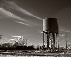
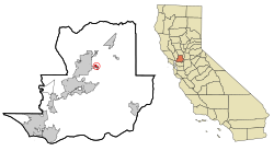
Elmira, California
Elmira | |
|---|---|
 | |
 Location in Solano County and the state of California | |
| Coordinates: 38°21′0″N 121°54′29″W / 38.35000°N 121.90806°W | |
| Country | United States |
| State | California |
| County | Solano |
| Government | |
| • State senator | Bill Dodd (D)[1] |
| • Assemblymember | Lori Wilson (D)[1] |
| • U.S. Congress | Kevin Kiley (R)[2] |
| Area | |
| • Total | 0.531 sq mi (1.376 km2) |
| • Land | 0.531 sq mi (1.376 km2) |
| • Water | 0 sq mi (0 km2) 0% |
| Elevation | 75 ft (23 m) |
| Population (2010) | |
| • Total | 188 |
| • Density | 350/sq mi (140/km2) |
| Time zone | UTC-8 (PST) |
| • Summer (DST) | UTC-7 (PDT) |
| ZIP code | 95625 |
| Area code | 707 |
| FIPS code | 06-22146 |
| GNIS feature ID | 1655995 |
Elmira is a census-designated place (CDP) in Solano County, California, United States. The population was 188 at the 2010 census.
History
[edit]Elmira, California, is named after Elmira, New York.[4][5]
In the 19th and early 20th century, Elmira was the major railroad stop between Fairfield and Davis.[6][7] To get to Vacaville, travelers had to take a spur from Elmira. When U.S. Route 40 was built through Vacaville, the population of Vacaville increased in size, while the population of Elmira declined.
Geography
[edit]According to the United States Census Bureau, the CDP has a total area of 0.531 square miles (1.38 km2), all of it land.[8]
Demographics
[edit]| Census | Pop. | Note | %± |
|---|---|---|---|
| U.S. Decennial Census[9] | |||
2010
[edit]The 2010 United States Census reported that Elmira had a population of 188.[10] The population density was 353.9 inhabitants per square mile (136.6/km2). The racial makeup of Elmira was 150 (79.8%) White, 10 (3.5%) African American, 10 (5.3%) Native American, 2 (1.1%) Asian, 0 (0.0%) Pacific Islander, 17 (9.0%) from other races, and 8 (4.3%) from two or more races.[10] Hispanic or Latino of any race were 47 people (25.0%).[10]
The whole population lived in households, no one lived in non-institutionalized group quarters and no one was institutionalized.[10]
There were 85 households, 20 (23.5%) had children under the age of 18 living in them, 34 (40.0%) were opposite-sex married couples living together, 6 (7.1%) had a female householder with no husband present, 7 (8.2%) had a male householder with no wife present. There were 6 (7.1%) unmarried opposite-sex partnerships, and 0 (0%) same-sex married couples or partnerships. 33 households (38.8%) were one person and 9 (10.6%) had someone living alone who was 65 or older. The average household size was 2.21.[11] There were 47 families (55.3% of households); the average family size was 3.00.[11]
The age distribution was 34 people (18.1%) under the age of 18, 14 people (7.4%) aged 18 to 24, 49 people (26.1%) aged 25 to 44, 65 people (34.6%) aged 45 to 64, and 26 people (13.8%) who were 65 or older.[10] The median age was 43.4 years.[11] The population was 54% male and 46% female.[11]
There were 91 housing units at an average density of 171.3 per square mile (66.1/km2), of which 45 (52.9%) were owner-occupied, and 40 (47.1%) were occupied by renters.[11] The homeowner vacancy rate was 0%; the rental vacancy rate was 7.0%. 101 people (53.7% of the population) lived in owner-occupied housing units and 87 people (46.3%) lived in rental housing units.
2000
[edit]At the 2000 census, there were 205 people, 86 households, and 52 families in the CDP.[12] The population density was 378.5 inhabitants per square mile (146.1/km2). There were 92 housing units at an average density of 169.8 per square mile (65.6/km2).[12] The racial makeup of the CDP was 87.80% White, 1.46% African American, 1.46% Pacific Islander, 6.34% from other races, and 2.93% from two or more races.[12] Hispanic or Latino of any race were 26.34% of the population.[12]
Of the 86 households 27.9% had children under the age of 18 living with them, 39.5% were married couples living together, 12.8% had a female householder with no husband present, and 39.5% were non-families.[12] 36.0% of households were one person and 7.0% were one person aged 65 or older.[12] The average household size was 2.38 and the average family size was 3.12.[12]
The age distribution was 24.9% under the age of 18, 7.8% from 18 to 24, 29.3% from 25 to 44, 29.8% from 45 to 64, and 8.3% 65 or older. The median age was 38 years. The population was 52.7% male and 47.3% female.[12]
The median household income was $48,438, based on a sample of the population.[13] The per capita income for the CDP was $35,397.[13] None of the families and 7.0% of the population were living below the poverty line.[13]
See also
[edit]References
[edit]- ^ a b "Statewide Database". UC Regents. Retrieved November 5, 2014.
- ^ "California's 3rd Congressional District - Representatives & District Map". Civic Impulse, LLC. Retrieved March 9, 2013.
- ^ U.S. Census Archived 2012-01-12 at the Wayback Machine
- ^ Gannett, Henry (1905). The Origin of Certain Place Names in the United States. Govt. Print. Off. pp. 118.
- ^ Hunt, Marguerite; Harry Lawrence Gunn (1926). "Suisun and Fairfield - Other Towns". History of Solano County and Napa County California. Chicago: The S. J. Clarke Publishing Co. Retrieved May 25, 2015.
- ^ Bowen, Jerry (November 25, 2001). "Elmira sits on the edge of history". Historical Articles of Solano County. Retrieved May 25, 2015.
- ^ Bowen, Jerry. "History of Solano County". Bella Vista Ranch. Retrieved May 25, 2015.
- ^ "National Places". United States Census Bureau. Archived from the original on January 12, 2012. Retrieved December 31, 2016.
- ^ "Census of Population and Housing". Census.gov. Retrieved June 4, 2016.
- ^ a b c d e "2010 Census Interactive Population Search: CA - Elmira CDP". U.S. Census Bureau. Archived from the original on July 15, 2014. Retrieved July 12, 2014.
- ^ a b c d e "Profile of General Population and Housing Characteristics: 2010". American FactFinder. United States Census Bureau. Archived from the original on February 13, 2020. Retrieved December 31, 2016.
- ^ a b c d e f g h "Profile of General Demographic Characteristics: 2000". American FactFinder. United States Census Bureau. Archived from the original on February 13, 2020. Retrieved December 30, 2016.
- ^ a b c "Profile of Selected Economic Characteristics: 2000". American FactFinder. United States Census Bureau. Archived from the original on February 13, 2020. Retrieved December 31, 2016.


